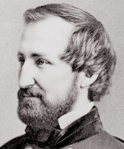
 Frederick Douglass gave a speech in Carlisle, Pennsylvania on March 2, 1872 about his work relating to Santo Domingo. In 1871 President Ulysses S. Grant had appointed Douglass to the Commission of Inquiry for the annexation of Santo Domingo the United States of America. Douglass delivered his speech at Rheem’s Hall, which was located behind the Old Court House in Carlisle. Today that location is a parking lot. Reports about the speech did not appear in any national newspapers, but his visit created a local controversy. George Z. Bentz, who was the manager of the Bentz House and a Republican, refused to let Douglass eat his dinner in hotel dining room with the white guests. (The Bentz House stood on what is today the former Wellington Hotel on East High Street). The American Volunteer used the incident to characterize Republicans as hypocritical. “We have in this circumstance positive evidence that the Radicals are just as loath to recognize negro-equality as the Democrats,” as the American Volunteer observed. While the Herald “[found] no fault with” the manager’s decision, the editors argued that policies which denied African Americans entry into a hotel “[were] simply silly and wicked.” In addition, Historic Carlisle recently added a Wayside Maker for Douglass’ visit.
20
Jun
10
 In its inaugural issue published on March 15, 1862 the New South, a weekly periodical with Northern sympathies, described the Union capture of Port Royal, South Carolina on November 7, 1861 as a “brisk little engagement with the enemy at Port Royal Ferry, in which the National forces, both Army and Navy manifested pluck and coolness the most desirable qualities in soldier’s or sailors.” This newspaper, which was highlighted in a previous post, documents life in occupied Port Royal through 1866 and is available online. As part of Union efforts to enforce the executive-mandated blockade on the South, Captain Samuel F. Du Pont, commander of the South Atlantic Blockading Squadron was sent to Port Royal, South Carolina where he helped capture Fort Walker and Fort Beauregard in the largest combined naval and military operation up to that point. The Civil War Blockade Strategy Board met during the summer of 1861 created a series of reports that informed the Union’s naval blockading strategy including Du Pont’s attack on Port Royal. Matthew Parker made these reports fully available on “Thomas Legion” a website that organizes Civil War primary documents for easy research. Other useful resources include the Library of Congress’s visual time line of the Civil War, which contains a collection of photographs from Port Royal, South Carolina from 1861 to 1865, a detailed essay on the battle of Port Royal, which appeared in the January 2001 issue of America’s Civil War.
18
Jun
10
Battle of Jenkins’ Ferry (April 30, 1864)
Published in Civil War (1861-1865), Images, Maps Themes: Battles & Soldiers
The Battle of Jenkins’ Ferry took place in Grant county, Arkansas on April 30, 1864 as Confederate forces attempted to Union General Frederick Steele’s forces retreated across the Saline River. While Confederates attacked several times, they could not stop Steele’s men from crossing the river with their supplies. Andrew F. Sperry, who served with the 33rd Iowa Infantry Regiment, described the battle after the war:
“The conflict was terrible to experience, but brief to tell. Seven mortal hours, with such fierce vigor and determination that the fire of musketry became one undistinguishable and unbroken roar. Charge after charge was made by the yelling rebels, only to be broken upon our line, or if possibly succeeding for a moment, to give way at last to a charge of still deeper and more deadly determination from our own brave men.”
Confederates “forgot…the valor of Steele’s soldiers,” as another Union veteran explained.
continue reading "Battle of Jenkins’ Ferry (April 30, 1864)"
18
Jun
10
 The Battle of Ball’s Bluff, also known as the Battle of Harrison’s Island or Battle of Leesburg was fought on October 21, 1861 in Loudoun County, Virginia. In response to movement by Confederate Colonel Nathan G. Evans, Union Major General George B. McClellan ordered Brigadier General Charles P. Stone to conduct a “slight demonstration,” a show of force from the Maryland side of the Potomac River without the intention of having any troops cross or combat. After a small encounter with Confederate troops, Union soldiers were ordered to cross over the river into Virginia. Without the necessarily amount of boats, Union soldiers were unable to successfully engage the enemy. This poorly coordinated attack combined with a vigorous counterattack from Confederate soldiers led to a disastrous defeat for the Union including the death of Colonel Edward D. Baker, a United States Senator from Oregon. Estimated casualties for the Union Army totaled over 900 while the Confederates suffered only 150. The defeat had substantial political consequences in Washington D.C. with the establishment of the Congressional Joint Committee on the Conduct of the War.
Ted Ballard’s book Battle of Ball’s Bluff published by the U.S. Army Center of Military History provides the most extensive overview of the battle with a detailed account of the battle including maps, images, bibliographical sketches and further readings . The Library of Congress offers a number of resources including images of Baker’s death and the Union retreat. The Abraham Lincoln Papers at the Library of Congress is another valuable resource that contains transcribed military telegrams between generals and the President. The Ball’s Bluff Battlefield Regional Park and National Cemetery provides visitors a chance to explore the battle site with hiking trails and signs throughout the park. The Northern Virginia Regional Park Authority website also offers worthwhile information regarding the battle including an overview, cultural resources, a downloadable self guided audio tour and detailed battle maps.
18
Jun
10
The Battle of Stones River (also known as the Battle of Murfreesboro) took place from December 31, 1862- January 3, 1863 in Rutherford County, Tennessee. Confederate General Braxton Bragg and the Army of Tennessee forced Union Major General William S. Rosecrans to the Nashville Pike, but the Union Army of the Cumberland was able to regain a strong position by crossing Stones River. The Confederate forces had to retreat and abandoned the battlefield on January 4-5. The National Park Service’s website provides an essay detailing the events of the battle and maps depicting troop movement. Other tools for teachers featured on the site are traveling trunks, lesson plans and teacher guides, and exhibits which provide students with an opportunity to learn about the Battle of Stones River interactively. The Civil War Preservation Trust’ s website includes a list of recommended books for the subject as well as several related historical articles. Also available on the website are historical maps and a photo gallery. Another selection on Google Books in limited view is No Better Place to Die: the Battle of Stones River as it gives a fairly detailed preview of the battle and there are also different reports from the battle’s commanding officers in Volume 20 of the Official Records. Alexander F. Stevenson commented on this event in his account of the battle:
“At 11 o’clock that night the rebel army commenced its retreat, and long before day break its infantry was miles away on the road towards Tullahoma and Shelbyville, while their cavalry withdrew slowly at daybreak, burning bridges as they moved south. While this retrograde movement of General Bragg’s army was going on, and each hour of this Sunday night was widening the distances between contending forces, our men lay in the muddy and rain-drenched ground, ready to attack at the earliest dawn to repel the enemy’s attacks. Soon, however, a report came, incredible at first, that the enemy had evacuated Murfreesboro’. Can it be true? was in everybody’s mouth, but few believed it; others argued that some hired spy had probably brought the news, to draw us out of our position, that the battle might be continued a few miles south of Murfreesboro’.”
18
Jun
10
 On August 10, 1861 about ten miles south of Springfield, Missouri Confederate forces under the joint command of General Benjamin McCulloch and Major General Sterling Price of the Missouri State Guard, defeated General Nathaniel Lyon’s Union troops at the battle of Wilson’s Creek. The National Park Service provides information geared towards teachers on their website, which highlights the field trip-friendly nature of the Wilson’s Creek battlefield. According to historian James McPherson, author of Battle Cry of Freedom, although the Confederate victory at Wilson’s Creek did not affect national public opinion, the battle had a direct impact on communities within Missouri. The Missouri State Senate officially declared Missouri’s secession from the Union on October 28, 1861, only three months after the battle at Wilson’s Creek. The Journal of the Missouri Senate’s Extra Session of the Rebel Legislature has been digitized as part of the Missouri Digital Heritage Initiative and is available here. Another rich online source for teachers exploring the Western theater of the Civil War is the website “Community and Conflict,” which documents the impact of the Civil War in the Ozarks from 1850 to 1875. By searching the Wilson’s Creek Collections researchers can access the journal of Captain Asbury C. Bradford of Company E, 2nd Regiment, 8th Division, Missouri State Guard, which includes Asbury’s hand-drawn map of the battle at Wilson’s Creek. Another unique resource is the memoir of Louisa Cheairs McKenny Sheppard, a 12-year-old resident of Springfield, who documented the effects of the Civil War on her family. The night before General Lyon was killed at Wilson’s Creek he dined at the McKenny home, an event that Louisa recorded in her memoir:
- “During dinner he [Lyon] raised his wine glass to Mother, and said, ‘Madam, you wish us success?’ ‘Sir,’ she answered with grave dignity, ‘I am a Southern woman.’ He looked at her in utter amazement, then said, ‘And you have sons in the Confederacy?’ Mother’s fine grey eyes were dark with trouble, as she made answer; ‘Four,’ then with a sudden flash of spirit, ‘and I wish they were fifty and I were leading them.’”
On August 10, 1861 about ten miles south of Springfield, Missouri Confederate forces under the joint command of General Benjamin McCulloch and Major General Sterling Price of the Missouri State Guard, defeated General Nathaniel Lyon’s Union troops at the battle of Wilson’s Creek. The National Park Service provides information geared towards teachers on their website, which highlights the field trip-friendly nature of the Wilson’s Creek battlefield. According to historian James McPherson, author of Battle Cry of Freedom, although the Confederate victory at Wilson’s Creek did not affect national public opinion, the battle had a direct impact on communities within Missouri. The Missouri State Senate officially declared Missouri’s secession from the Union on October 28, 1961, only three months after the battle at Wilson’s Creek. The Journal of the Missouri Senate’s Extra Session of the Rebel Legislature has been digitized as part of the Missouri Digital Heritage Initiative and is available here. Another rich online source for teachers exploring the Western theater of the Civil War is the website “Community and Conflict,” which documents the impact of the Civil War in the Ozarks from 1850 to 1875. By searching the Wilson’s Creek Collections researchers can access the journal of Captain Asbury C. Bradford of Company E, 2nd Regiment, 8th Division, Missouri State Guard, which includes Asbury’s hand-drawn map of the battle at Wilson’s Creek. Another unique resource is the memoir of Louisa Cheairs McKenny Sheppard, a 12-year-old resident of Springfield, who documented the effects of the Civil War on her family. The night before General Lyon was killed at Wilson’s Creek he dined at the McKenny home, an event that Louisa recorded in her memoir:
“During dinner he [Lyon] raised his wine glass to Mother, and said, ‘Madam, you wish us success?’ ‘Sir,’ she answered with grave dignity, ‘I am a Southern woman.’ He looked at her in utter amazement, then said, ‘And you have sons in the Confederacy?’ Mother’s fine grey eyes were dark with trouble, as she made answer; ‘Four,’ then with a sudden flash of spirit, ‘and I wish they were fifty and I were leading them.’”
16
Jun
10

General William T. Sherman’s March to the Sea, also known as the Savannah Campaign, began on November 15 when Sherman’s forces left Atlanta, Georgia. The Confederate defeat at Savannah on December 21, 1864 marked the end of the campaign. Teachers can find an overview of this campaign in Professor Anne Bailey’s entry on the New Georgia Encyclopedia. The Library of Congress also has a number of related resources, including battle maps, photographs, and illustrations. In addition, the Digital Library of Georgia has all of the images from Barnard’s Photographic Views of the Sherman Campaign (1866), including several pictures of Savannah. Lt. Cornelius C. Platter’s diary, which was noted in an earlier post, is another resource that offers an interesting perspective on a Union officer’s experience. Platter, who served with the 81st Ohio Infantry Volunteers, added an entry on almost every day of the campaign. As his company prepared for their “marching orders” in early November, Platter described:
“Many different opinions have been expressed as to our probable destination – Some think we will make direct for Charleston S.C. others that we will visit Mobile – but the most general belief is that Savannah will be the objective point – Nothing definite however is known concerning the coming movement. Received orders this evening to move at six o’clock tomorrow morning – All tents and other government property which we can not take with us to be left standing undisturbed.”
continue reading "General Sherman’s March to the Sea (November – December 1864)"
16
Jun
10

The Battle of Cold Harbor (also known as Second Cold Harbor) took place in Hanover County, Virginia from May 31-June 12, 1864. As a part of the overland campaign to Richmond of 1864 General Robert E. Lee and the Confederate Army of Northern Virginia defeated Ulysses S. Grant and the Army of the Potomac. On June 3, the Union II, XVIII, and IX Corps attacked the Confederates at the Bethesda Church-Cold Harbor line and were massacred. The casualties sustained by the Union Army led Grant to say that “this charge seemed to revive [Confederate] hopes temporarily.” The National Park Service’s website provides an overview of the battle that recounts the day to day activity of the fighting as well as a list of Union and Confederate troops present at the battle. The National Parks Service’s website also includes a list of suggested readings for teachers and offers interactive travel trunks that are available for loan to classes. There is a link available that presents visitors with a map of different stops throughout a tour of the battlefield and gives suggestions for teachers to plan a fieldtrip to the battleground. The Civil War Preservation Trust ’s website has links to suggested readings, online resources, and battle facts about the events at Cold Harbor. The site includes a map that details the plan of battle for the Union and Confederate forces. Another resource that may be interesting to browse is Gordon C. Rhea’s Cold Harbor: Grant and Lee, May 26-June 3, 1864 , available in limited view on Google Books, which gives a rather detailed preview regarding the events of the battle. Grant commented on the battle in his memoirs:
“I have always regretted that the last assault on Cold Harbor was ever made. I might say the same thing of the assault of the 22 of May, 1863, at Vicksburg. At Cold Harbor no advantage was ever gained to compensate for the heavy loss we sustained. Indeed, the advantages other than those of relative losses, were on the Confederate side.”
15
Jun
10
Battle of Harpers Ferry – September 12–15, 1862
Published in Civil War (1861-1865), Historic Periodicals, Images, Maps Themes: Battles & Soldiers In October 1909 Union veteran Edward Ripley argued that the Union’s defeat at the Battle of Harpers Ferry (September 15-17, 1862) was a “tragedy:”
“It is not too exaggerated a term to use where 12,000 brave and patriotic Americans, only too willing to serve their country, were bound hand and foot by an incompetent commander and, in spite of indignant protest, handed over to the enemy.”
After General Robert E. Lee invaded Maryland, he sent General Thomas “Stonewall” Jackson to capture the federal arsenal at Harpers Ferry. Col. Dixon S. Miles ordered his forces to retreat into the town in response to Jackson’s attack, which Col. Dixon S. Miles’s response. After the war Union General Julius White argued that “[Col. Miles] had lost all confidence in his ability” and explained that the high ground around Harpers Ferry was critical to defense: “Harper’s Ferry is not defensible by a force inferior to that attacking it, unless the surrounding heights be well fortified, and each of them held by a force sufficient to maintain itself unsupported by others.”
Teachers can learn more about this battle from a short essay and related maps on the National Parks Service website. This site, which also focuses on John Brown’s attack in October 1859, also has a virtual tour and a collection of over 300 images (not all are related to the battle). Anyone planning a visit should check out the detailed information in the “Self Guided” and “Ranger Guided” sections of “Plan a Field Trip” page. Other resources are available from the Library of Congress, including historic maps, photographs, and illustrations by Alfred Waud. In addition, Cornell University’s Making of America has two articles written after the war by Confederate generals John Imboden and John Walker. Union General Julius White, whose article is referenced above, wrote it in response to these Confederate officers’ accounts, which he considered “incomplete.”
15
Jun
10
 On the morning of June 19, 1864, before the naval battle with the USS Kearsarge Captain Raphael Semmes of the CSS Alabama, in an impassioned address, spoke to his crew:
- “you have been all over the world and it is not too much to say that you have destroyed and driven for protection under neutral flags one half of the enemy’s commerce which at the beginning of the war covered every sea This is an achievement of which you may well be proud and a grateful country will not be unmindful of it The name of your ship has become a household word wherever civilization extends Shall that name be tarnished by defeat The thing is impossible Remember that you are in the English Channel the theatre of so much of the naval glory of our race and that the eyes of all Europe are at this moment upon you The flag that floats over you is that of a young Republic who bids defiance to her enemies whenever and wherever found Show the world that you know how to uphold it.”
Semmes recorded his personal experiences as the captain of CSS Alabama and Sumter in his personal memoir My Adventures Afloat … (1869), available on Google Books. Captain Semmes’ stirring speech did not stop the USS Kearsarge on June 19, 1684 from sinking the Alabama and putting an end to her formidable record. In less than two years the CSS Alabama, a Confederate ship that engaged in commerce raiding by destroying Union merchant ships, sunk 62 ships including the USS Hatteras. The Naval History & Heritage Command, an agency of the Department of the Navy, outlines the history of the ship in an educational website that includes a wide range of resources for classroom use. Students can view images of the battle as published in contemporary newspapers, read excerpts from the official reports of both the Union Captain John Winslow and the Confederate Captain Semmes, or explore recent press releases about the underwater archaeological work being conducted on the wreck since its discovery in 1988 off the coast of France. For other resources, see Historyofwar.org , where they provide maps of the CSS Alabama’s routes and of the battle with the USS Kearsarge.
[flickrslideshow acct_name=”housedivided” id=”72157624282521058″]


