• Home
  • About
  • How to Contribute
  • Our Correspondents

18

Jun

10

The Battle of Ball’s Bluff, October 21, 1861

Posted by rainwatj  Published in Civil War (1861-1865), Images, Letters & Diaries, Maps, Places to Visit Themes: Battles & Soldiers

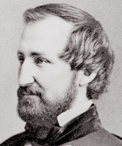
The Battle of Ball’s Bluff, also known as the Battle of Harrison’s Island or Battle of Leesburg was fought on October 21, 1861 in Loudoun County, Virginia. In response to movement by Confederate Colonel Nathan G. Evans, Union Major General George B. McClellan ordered Brigadier General Charles P. Stone to conduct a “slight demonstration,” a show of force from the Maryland side of the Potomac River without the intention of having any troops cross or combat. After a small encounter with Confederate troops, Union soldiers were ordered to cross over the river into Virginia. Without the necessarily amount of boats, Union soldiers were unable to successfully engage the enemy. This poorly coordinated attack combined with a vigorous counterattack from Confederate soldiers led to a disastrous defeat for the Union including the death of Colonel Edward D. Baker, a United States Senator from Oregon. Estimated casualties for the Union Army totaled over 900 while the Confederates suffered only 150. The defeat had substantial political consequences in Washington D.C. with the establishment of the Congressional Joint Committee on the Conduct of the War.

Ted Ballard’s book Battle of Ball’s Bluff published by the U.S. Army Center of Military History provides the most extensive overview of the battle with a detailed account of the battle including maps, images, bibliographical sketches and further readings . The Library of Congress offers a number of resources including images of Baker’s death and the Union retreat. The Abraham Lincoln Papers at the Library of Congress is another valuable resource that contains transcribed military telegrams between generals and the President. The Ball’s Bluff Battlefield Regional Park and National Cemetery provides visitors a chance to explore the battle site with hiking trails and signs throughout the park. The Northern Virginia Regional Park Authority website also offers worthwhile information regarding the battle including an overview, cultural resources, a downloadable self guided audio tour and detailed battle maps.


no comment

18

Jun

10

The Battle of Stones River, December 31, 1862- January 3, 1863

Posted by mckelveb  Published in Civil War (1861-1865), Images, Lesson Plans, Maps Themes: Battles & Soldiers

The Battle of Stones River (also known as the Battle of Murfreesboro) took place from December 31, 1862- January 3, 1863 in Rutherford County, Tennessee.  Confederate General Braxton Bragg and the Army of Tennessee forced Union Major General William S. Rosecrans to the Nashville Pike, but the Union Army of the Cumberland was able to regain a strong position by crossing Stones River.  The Confederate forces had to retreat and abandoned the battlefield on January 4-5.  The National Park Service’s website provides an essay detailing the events of the battle and maps depicting troop movement.  Other tools for teachers featured on the site are traveling trunks, lesson plans and teacher guides, and exhibits which provide students with an opportunity to learn about the Battle of Stones River interactively.  The Civil War Preservation Trust’ s website includes a list of recommended books for the subject as well as several related historical articles.  Also available on the website are historical maps and a photo gallery.  Another selection on Google Books in limited view is No Better Place to Die: the Battle of Stones River as it gives a fairly detailed preview of the battle and there are also different reports from the battle’s commanding officers in Volume 20 of the Official Records. Alexander F. Stevenson commented on this event in his account of the battle:

“At 11 o’clock that night the rebel army commenced its retreat, and long before day break its infantry was miles away on the road towards Tullahoma and Shelbyville, while their cavalry withdrew slowly at daybreak, burning bridges as they moved south.  While this retrograde movement of General Bragg’s army was going on, and each hour of this Sunday night was widening the distances between contending forces, our men lay in the muddy and rain-drenched ground, ready to attack at the earliest dawn to repel the enemy’s attacks.  Soon, however, a report came, incredible at first, that the enemy had evacuated Murfreesboro’.  Can it be true? was in everybody’s mouth, but few believed it; others argued that some hired spy had probably brought the news, to draw us out of our position, that the battle might be continued a few miles south of Murfreesboro’.”

no comment

18

Jun

10

The Battle of Wilson’s Creek, August 10, 1861

Posted by solnitr  Published in Civil War (1861-1865), Letters & Diaries, Maps, Recent Scholarship Themes: Battles & Soldiers

On August 10, 1861 about ten miles south of Springfield, Missouri Confederate forces under the joint command of General Benjamin McCulloch and Major General Sterling Price of the Missouri State Guard, defeated General Nathaniel Lyon’s Union troops at the battle of Wilson’s Creek. The National Park Service provides information geared towards teachers on their website, which highlights the field trip-friendly nature of the Wilson’s Creek battlefield. According to historian James McPherson, author of Battle Cry of Freedom, although the Confederate victory at Wilson’s Creek did not affect national public opinion, the battle had a direct impact on communities within Missouri. The Missouri State Senate officially declared Missouri’s secession from the Union on October 28, 1861, only three months after the battle at Wilson’s Creek. The Journal of the Missouri Senate’s Extra Session of the Rebel Legislature has been digitized as part of the Missouri Digital Heritage Initiative and is available here.  Another rich online source for teachers exploring the Western theater of the Civil War is the website “Community and Conflict,” which documents the impact of the Civil War in the Ozarks from 1850 to 1875. By searching the Wilson’s Creek Collections researchers can access the journal of Captain Asbury C. Bradford of Company E, 2nd Regiment, 8th Division, Missouri State Guard, which includes Asbury’s hand-drawn map of the battle at Wilson’s Creek. Another unique resource is the memoir of Louisa Cheairs McKenny Sheppard, a 12-year-old resident of Springfield, who documented the effects of the Civil War on her family. The night before General Lyon was killed at Wilson’s Creek he dined at the McKenny home, an event that Louisa recorded in her memoir:

  • “During dinner he [Lyon] raised his wine glass to Mother, and said, ‘Madam, you wish us success?’ ‘Sir,’ she answered with grave dignity, ‘I am a Southern woman.’ He looked at her in utter amazement, then said, ‘And you have sons in the Confederacy?’ Mother’s fine grey eyes were dark with trouble, as she made answer; ‘Four,’ then with a sudden flash of spirit, ‘and I wish they were fifty and I were leading them.’”

On August 10, 1861 about ten miles south of Springfield, Missouri Confederate forces under the joint command of General Benjamin McCulloch and Major General Sterling Price of the Missouri State Guard, defeated General Nathaniel Lyon’s Union troops at the battle of Wilson’s Creek. The National Park Service provides information geared towards teachers on their website, which highlights the field trip-friendly nature of the Wilson’s Creek battlefield. According to historian James McPherson, author of Battle Cry of Freedom, although the Confederate victory at Wilson’s Creek did not affect national public opinion, the battle had a direct impact on communities within Missouri. The Missouri State Senate officially declared Missouri’s secession from the Union on October 28, 1961, only three months after the battle at Wilson’s Creek. The Journal of the Missouri Senate’s Extra Session of the Rebel Legislature has been digitized as part of the Missouri Digital Heritage Initiative and is available here. Another rich online source for teachers exploring the Western theater of the Civil War is the website “Community and Conflict,” which documents the impact of the Civil War in the Ozarks from 1850 to 1875. By searching the Wilson’s Creek Collections researchers can access the journal of Captain Asbury C. Bradford of Company E, 2nd Regiment, 8th Division, Missouri State Guard, which includes Asbury’s hand-drawn map of the battle at Wilson’s Creek. Another unique resource is the memoir of Louisa Cheairs McKenny Sheppard, a 12-year-old resident of Springfield, who documented the effects of the Civil War on her family. The night before General Lyon was killed at Wilson’s Creek he dined at the McKenny home, an event that Louisa recorded in her memoir:

“During dinner he [Lyon] raised his wine glass to Mother, and said, ‘Madam, you wish us success?’ ‘Sir,’ she answered with grave dignity, ‘I am a Southern woman.’ He looked at her in utter amazement, then said, ‘And you have sons in the Confederacy?’ Mother’s fine grey eyes were dark with trouble, as she made answer; ‘Four,’ then with a sudden flash of spirit, ‘and I wish they were fifty and I were leading them.’”

no comment

16

Jun

10

General Sherman’s March to the Sea (November – December 1864)

Posted by sailerd  Published in Civil War (1861-1865), Images, Letters & Diaries, Maps Themes: Battles & Soldiers

General William T. Sherman’s March to the Sea, also known as the Savannah Campaign, began on November 15 when Sherman’s forces left Atlanta, Georgia. The Confederate defeat at Savannah on December 21, 1864 marked the end of the campaign. Teachers can find an overview of this campaign in Professor Anne Bailey’s entry on the New Georgia Encyclopedia. The Library of Congress also has a number of related resources, including battle maps, photographs, and illustrations. In addition, the Digital Library of Georgia has all of the  images from  Barnard’s Photographic Views of the Sherman Campaign (1866), including several pictures of Savannah. Lt. Cornelius C. Platter’s diary, which was noted in an earlier post, is another resource that offers an interesting perspective on a Union officer’s experience. Platter, who served with the 81st Ohio Infantry Volunteers, added an entry on almost every day of the campaign. As his company prepared for their “marching orders” in early November, Platter described:

“Many different opinions have been expressed as to our probable destination – Some think we will make direct for Charleston S.C. others that we will visit Mobile – but the most general belief is that Savannah will be the objective point – Nothing definite however is known concerning the coming movement. Received orders this evening to move at six o’clock tomorrow morning – All tents and other government property which we can not take with us to be left standing undisturbed.”


continue reading "General Sherman’s March to the Sea (November – December 1864)"

no comment

16

Jun

10

Battle of Cold Harbor, May 31-June 12, 1864

Posted by mckelveb  Published in Civil War (1861-1865), Images, Letters & Diaries, Maps, Recent Scholarship Themes: Battles & Soldiers

The Battle of Cold Harbor (also known as Second Cold Harbor) took place in Hanover County, Virginia from May 31-June 12, 1864.  As a part of the overland campaign to Richmond of 1864 General Robert E. Lee and the Confederate Army of Northern Virginia defeated Ulysses S. Grant and the Army of the Potomac.  On June 3, the Union II, XVIII, and IX Corps attacked the Confederates at the Bethesda Church-Cold Harbor line and were massacred.  The casualties sustained by the Union Army led Grant to say that  “this charge seemed to revive [Confederate] hopes temporarily.”  The National Park Service’s  website provides an overview of the battle that recounts the day to day activity of the fighting as well as a list of Union and Confederate troops present at the battle.  The National Parks Service’s website also includes a list of suggested readings for teachers and offers interactive travel trunks that are available for loan to classes.  There is a link available that presents visitors with a map  of different stops throughout a tour of the battlefield and gives suggestions for teachers to plan a fieldtrip to the battleground.  The Civil War Preservation Trust ’s website has links to suggested readings, online resources, and battle facts about the events at Cold Harbor.  The site includes a map that details the plan of battle for the Union and Confederate forces.  Another resource that may be interesting to browse is Gordon C. Rhea’s Cold Harbor: Grant and Lee, May 26-June 3, 1864 , available in limited view on Google Books, which gives a rather detailed preview regarding the events of the battle.  Grant commented on the battle in his memoirs:

“I have always regretted that the last assault on Cold Harbor was ever made.  I might say the same thing of the assault of the 22 of May, 1863, at Vicksburg.  At Cold Harbor no advantage was ever gained to compensate for the heavy loss we sustained.  Indeed, the advantages other than those of relative losses, were on the Confederate side.”

no comment

15

Jun

10

Battle of Harpers Ferry – September 12–15, 1862

Posted by sailerd  Published in Civil War (1861-1865), Historic Periodicals, Images, Maps Themes: Battles & Soldiers

In October 1909 Union veteran Edward Ripley argued that the Union’s defeat at the Battle of Harpers Ferry (September 15-17, 1862) was a “tragedy:”

“It is not too exaggerated a term to use where 12,000 brave and patriotic Americans, only too willing to serve their country, were bound hand and foot by an incompetent commander and, in spite of indignant protest, handed over to the enemy.”

After General Robert E. Lee invaded Maryland, he sent General Thomas “Stonewall” Jackson to capture the federal arsenal at Harpers Ferry. Col. Dixon S. Miles ordered his forces to retreat into the town in response to Jackson’s attack, which Col. Dixon S. Miles’s response. After the war Union General Julius White argued that “[Col. Miles] had lost all confidence in his ability” and explained that the high ground around Harpers Ferry was critical to defense: “Harper’s Ferry is not defensible by a force inferior to that attacking it, unless the surrounding heights be well fortified, and each of them held by a force sufficient to maintain itself unsupported by others.”
Teachers can learn more about this battle from a short essay and related maps on the National Parks Service website. This site, which also focuses on John Brown’s attack in October 1859, also has a virtual tour and a collection of over 300 images (not all are related to the battle). Anyone planning a visit should check out the detailed information in the “Self Guided” and “Ranger Guided” sections of “Plan a Field Trip” page. Other resources are available from the Library of Congress, including historic maps, photographs, and illustrations by Alfred Waud. In addition, Cornell University’s Making of America has two articles written after the war by Confederate generals John Imboden and John Walker. Union General Julius White, whose article is referenced above, wrote it in response to these Confederate officers’ accounts, which he considered “incomplete.”

no comment

15

Jun

10

The Battle of Olustee (Ocean Pond): February 20, 1864

Posted by rainwatj  Published in Civil War (1861-1865), Historic Periodicals, Images, Letters & Diaries, Maps, Places to Visit Themes: Battles & Soldiers

The Battle of Olustee took place on February 20, 1864 in Baker County, Florida where the Union Army under Brigadier General Truman B. Seymour was defeated and forced to retreat back to Jacksonville in the largest battle fought in Florida during the American Civil War.  Under Brigadier General Joseph Finegan, the reinforced Confederate soldiers inflicted massive casualties on Union troops. Estimates on both sides list the total casualties for the Union Army at 1,860, almost 40% of the participating soldiers and 946 Confederate casualties, 20% of their soldiers at Olustee. Seymour’s army was notable for the participation of three colored regiments; the 8th United States Colored Troops, the 35th United States Colored Troops and the 54th Massachusetts Infantry. For more information on these regiments during Olustee, check out portions of J. Matthew Gallman’s chapter in Wars within a War: Controversy and Conflict over the  American Civil War. Other documents of interest related to the Battle of Olustee can be found in volume 35 of the Official Records.

The most extensive collection of resources can be found at the Battle of Olustee site developed by Thomas R. Fasulo which includes primary sources such as official reports, maps, letters, diaries, images, speeches and periodicals. The Olustee Battlefield Historic State Park commemorates the battle and offers visitors a chance to immerse themselves through walking tours of the battlefield and a visitor center with historical information and artifacts. There is an annual reenactment of the battle in February and a Civil War Expo in September that provides visitors an authentic experience of the battle with hands on activities and historical reenactments


no comment

11

Jun

10

Battle of Kennesaw Mountain

Posted by sailerd  Published in Civil War (1861-1865), Images, Letters & Diaries, Maps, Places to Visit Themes: Battles & Soldiers

The Battle of Kennesaw Mountain took place on June 27, 1864 in Cobb county, Georgia when General William T. Sherman ordered his forces to attack General Joseph E. Johnston’s Army of Tennessee. Sherman, who was unable to dislodge Johnston’s men, was forced to withdraw  later that day. Some estimates put the number of total casualties at 4,000 (3,000 Union, 1,00 CSA). Teachers will find several resources on the National Park Service’s site, including a short overview of the battle and a Google Earth Tour. This viritual tour shows the location of the Confederate and Union forces on the battlefield as well as hiking and horse trails. The Library of Congress also has some resources , including several sketches by Alfred R. Waud and several maps of General Sherman’s Atlanta Campaign. In addition, Google Books has several interesting accounts of the battle. William Chamberlin, who served with the Ohio Infantry Volunteers, decribed the impact on his regiment:

“Kennesaw Mountain! What soldier who saw it during these days will ever forget its fiery flaming brow? Into how many households does the name bring the gushing tears of sorrow for the loved one whose spark of life went out before that death-dealing giant of Nature? Kennesaw Mountain held Sherman’s army at bay fourteen days during which the loss in killed and wounded was greater than at any previous part of the campaign.”

Lieutenant Warren, who served in the Missouri Confederate Brigade, described the “poor fellows” in the “solid line of blue” whose attack was repulsed. One can find other primary sources related to this battle in Cornell University’s Making of America, including General Johnston’s account and other reports in the Official Records.

no comment

9

Jun

10

Siege of Port Hudson

Posted by sailerd  Published in Civil War (1861-1865), Images, Lesson Plans, Letters & Diaries, Maps Themes: Battles & Soldiers

The Siege of Port Hudson began in late May 1863 with a series of battles, including one on May 27 that was among the first major engagements that involved African American regiments. After General Franklin Gardner received reports that confirmed the Confederate defeat at Vicksburg, he surrendered his forces to General Nathaniel P. Banks on July 9, 1863. Some estimates put the total number of casualties during the siege at 12,208 (Union 5,000 / CSA 7,208). The National Park Service offers a great lesson plan about Port Hudson through their Teaching with Historic Places program. Teachers will find a short overview of the battle, several accounts from soldiers who participated in the battle, and links to several photographs. Louisiana State University’s Marshall Dunham photograph album also has a number of photographs of Port Hudson. In addition, several battle maps are available from the Library of Congress. Port Hudson may not be that well known, but as General Ulysses S. Grant explained in his Personal Memoirs (1885-1886), the Union’s victory on July 9 was a significant one. “From that day to the close of the rebellion the Mississippi River, from its source to its mouth, remained in the control of the National troops,” as Grant noted. You can also find other documents about this battle in volume 26 of the Official Records. (A list of all the reports starts on page 41).

no comment

8

Jun

10

The First Battle of Bull Run, July 21, 1861

Posted by solnitr  Published in Civil War (1861-1865), Historic Periodicals, Images, Lesson Plans, Maps, Places to Visit Themes: Battles & Soldiers

The artist H. Lovie captured a strange scene on July 21, 1861 in Manassas, Virginia: civilians sitting on a hill overlooking the clash between the Union and Confederate armies.  Lovie’s picture was published in Frank Leslie’s weekly illustrated newspaper, a great visual resource for documenting the Civil War. Both the picnicking residents of Washington DC and Gen. Irvin McDowell’ s troops were unprepared for the hard-fought and bloody Confederate victory at the First Battle of Bull Run (Manassas).  With nearly 5,000 combined casualties, this early battle deflated Northern hopes of a quick and easy war.  General Joseph E. Johnston, commander of the Confederate Armies of the Shenandoah and of the Potomac reflected on their unlikely victory:
  • The admirable character of our troops is incontestably proved by the result of this battle, especially when it is remembered that little more than six thousand men of the Army of the Shenandoah with sixteen guns, and less than two thousand of that of the Potomac with six guns, for full five hours successfully resisted thirty-five thousand U. S. troops with a powerful artillery and superior force of regular cavalry… The unfading honor which they won was dearly bought with the blood of many of our best and bravest.
The Virginia Center for Digital History has created a valuable online resource in their project entitled “Valley of the Shadow” which examines the Civil War through the eyes of Americans on both sides of the conflict. Students can study the 1st Battle at Bull Run by watching 5th Virginia Infantry and 1st Virginia Cavalry’s advance into the battle in the interactive map, read reports by commanding officers, or skim a Pennsylvania newspaper published the weekend following the battle.  The battlefield is preserved by the National Park Service as a national battlefield, and the NPS website provides tools for teachers including lesson plans and field trip outlines.
David Harrison Walton, Dickinson College Class of 1854, fought as part of the Stonewall Brigade during the first Battle at Manassas, as the first commander of the “Shenandoah Sharpshooters”: Company K of the 33rd Virginia.
[flickrslideshow acct_name=”Housedivided” id=”72157624115696017″]
1 comment
Page 3 of 6«12345...»Last »

Search

Categories

  • Dickinson & Slavery
  • History Online
  • Period
    • 19th Century (1840-1880)
    • Antebellum (1840-1861)
    • Civil War (1861-1865)
    • Reconstruction (1865-1880)
  • Type
    • Editor's Choice
    • General Opinion
    • Historic Periodicals
    • Images
    • Lesson Plans
    • Letters & Diaries
    • Lists
    • Maps
    • Places to Visit
    • Rare Books
    • Recent News
    • Recent Scholarship
    • Recollections
    • Video
  • What Would Lincoln Do?

Project Links

  • Digital Lincoln
  • HDiv Research Engine
  • House Divided Index
  • L-D Debates Classroom
  • Lincoln in PA
  • PA Grand Review
  • UGRR Classroom
  • Virtual Field Trips
  • William Stoker Exhibit

Administration

  • Log in
  • Entries feed
  • Comments feed
  • WordPress.org
Donate

Recent Post

  • Black Employees and Exclusive Spaces: The Dickinson Campus in the Late 19th Century
  • Friend or Foe: Nineteenth Century Dickinson College Students’ Perception of Their Janitors
  • Teaching Gettysburg: New Classroom Resources
  • Coverage of the Gettysburg Address
  • Welcome to Chicago: Choosing the Right Citation Generator
  • Augmented Reality in the Classroom
  • Beyond Gettysburg: Primary Sources for the Gettysburg Campaign
  • African Americans Buried at Gettysburg
  • The Slave Hunt: Amos Barnes and Confederate Policy
  • Entering Oz – Bringing Color to History

Recent Comments

  • George Georgiev in Making Something to Write Home About
  • Matthew Pinsker in The Slave Hunt: Amos Barnes and Confederate Policy…
  • linard johnson in Making Something to Write Home About
  • Bedava in The Slave Hunt: Amos Barnes and Confederate Policy…
  • Adeyinka in Discovering the Story of a Slave Catcher
  • Stefan Papp Jr. in Where was William Lloyd Garrison?
  • Stefan Papp Jr. in Where was William Lloyd Garrison?
  • Jon White in Albert Hazlett - Trial in Carlisle, October 1859
  • Pedro in Discovering the Story of a Slave Catcher
  • Matthew Pinsker in Register Today for "Understanding Lincoln," a New …

by Wired Studios, Corvette Garage, Jeff Mummert
© Content 2007-2010 by Dickinson College