• Home
  • About
  • How to Contribute
  • Our Correspondents

4

Nov

09

Digital History – Edward Ayers

Posted by sailerd  Published in 19th Century (1840-1880), Images, Maps Themes: US & the World

digitalhistory_ex2

The history department at the University of Nebraska has a number of lectures on digital history projects available, including Edward Ayers’ “Civil War and Emancipation: Visualizing American History.” Ayers, who developed the Valley of the Shadow, discusses that project as well as the Emancipation Project and the Southern History Database. While a transcript is not available, Ayers also presents his ideas in a short essay, “Mapping Freedom.” Digital history projects like the Valley of the Shadow allow historians to “bore down to the stories of individual people and families and, as Ayers explains, in this case “see how people held in bondage created new lives for themselves.” Also be sure to check out the interviews with other historians who share their thoughts on digital history.

no comment

28

Oct

09

Civil War Maps

Posted by   Published in Civil War (1861-1865), Images, Maps Themes: Battles & Soldiers

The Library of Congress’ American Memory has constructed an interactive database containing over 3,000 maps from the Civil War era. The collection offers detailed descriptions of a variety of topics such as Union General William Tecumseh Sherman’s successful Atlanta Campaign to an outline of 23 forts defending the Confederatecivilwar_map2 capital of Richmond, Virginia. Another great tool within the database is the fact that each map contains a list of subject links that help to expand upon your research. The collection contains map collections originally owned by both Union and Confederate military authorities.

American Memory has other databases that can prove useful in your research. Civil War railroad maps show an intricate description of the development of railroads through 1900.  There is also a collection of over 1,000 photographs from the Civil War era that have been specifically selected due to their innate detail.

no comment

28

Oct

09

“Voting America: United States Politics, 1840-2004”

Posted by sailerd  Published in Antebellum (1840-1861), Maps Themes: Contests & Elections

votingThe University of Richmond Digital Scholarship Lab’s “Voting America” is great resource on US Presidential elections. The site provides a series of maps on each election between 1840 and 2004  that show a variety of different information. For example, the 1860 election map includes layers that breakdown the popular vote by county and counties with small margins of victories (when a second place candidate lost by less than 10 percent of the vote). The site also organizes the maps by topic, such as turnout and third party voting. In addition, this interactive map allows you to select the election data that appears. Also, be sure to check out all of the videos – including this one with Professor Edward Ayers who discusses the elections before the Civil War.

no comment

13

Oct

09

Impact and Development of Railroads in the North and South

Posted by   Published in Antebellum (1840-1861), Historic Periodicals, Lesson Plans, Letters & Diaries, Maps Themes: Business & Industry

The Valley of the Shadow

Though previously mentioned in another post, the The Valley of the Shadow Project has a wide range of primary sources from newspapers, maps, letters, and statistics all available for use in the 7-12 classroom. Broken up chronologically into three periods, the Project archives two communities (Augusta County, Virginia and Franklin County, Pennsylvania) between the years of 1859 and 1870. A particularly good lesson plan by Alice Carter compares the impact and the development of the railroads in both counties using various articles from historical newspapers. The lesson provides a teacher with preselected articles, however, one may choose to either find newspaper accounts that reflect individual class interests or allow students to search for their own, using the newspaper indexes. One special note: teachers could extend the lesson and explore the impact of railroads during reconstruction.

2 comments

25

Aug

09

Digitizing the Lincoln Administration

Posted by   Published in Civil War (1861-1865), Images, Lesson Plans, Letters & Diaries, Maps Themes: Laws & Litigation

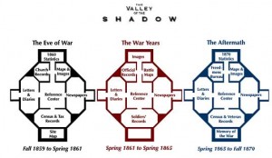
Among the many websites and digital projects bringing the 19th century to the World Wide Web is the Lincoln Archives Digital Project from researcher Karen Needles. This ambitious project began in 2002 with the goal of digitizing all federal records from the Lincoln administration, including every cabinet and every agency. The project is the first of its kind to digitize the holdings of an entire administration and its standards are high. The project uses high resolution scans of original documents from the National Archives and incorporates technology such as “Zoomify” to create a high quality and easily accessible collection.

The project is not limited to just federal documents and includes maps, newspapers, photographs, political cartoons, blogs, lesson plans and even a dictionary and who’s who of the period. The wealth of information is seemingly endless and is always growing, although a subscription is required for full access to the project. For more information, check out the project and the August article about it in Civil War News.

1 comment

26

Jun

09

Lincoln in Ottawa

Posted by parkd  Published in Antebellum (1840-1861), Maps, Places to Visit Themes: Contests & Elections

Interested in all things Lincoln?  The city of Ottawa, Illinois’ webpage houses a pdf entitled The OttawaLincoln Knew.  This file pulls most of its information from Aletia Tisler’s book, “Lincoln was Here,” using only facts and anecdotes pertinent to the town of Ottawa.  Although the section focuses mainly upon the Lincoln-Douglas debate that took place there in 1858, it also showcases Lincoln’s first meeting with Douglas in the courtroom.  At the bottom of the file, the site includes a map of modern day Illinois with location markers that specify places made famous by Lincoln’s presence.  This site would be especially helpful for someone trying to create a unique family vacation seeped in history.

no comment

22

Jun

09

Lincoln-Douglas Debates Resource for Teachers

Posted by parkd  Published in Antebellum (1840-1861), Lesson Plans, Maps Themes: Contests & Elections

Lincoln Douglas DebatesThe Northern University of Illinois page, The Lincoln/Douglas Debates of 1858, offers wide-ranging coverage of the historic oratory campaign. The site houses numerous primary documents including debate transcripts, maps, and contemporary press coverage. Also, The Lincoln/Douglas Debates of 1858 provides a video podcast on the debates by Columbia’s Eric Foner as well as lessons plans for teachers that include brief descriptions of the debate topics and guided reading assignments for students. This site would be a great addition to any history teacher’s repertoire of resources.

5 comments

2

Jun

09

Have a story about a local Underground Railroad stop?

Posted by   Published in Antebellum (1840-1861), Images, Maps Themes: Slavery & Abolition

UGRR
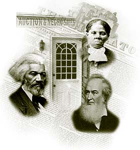
The National Park Service is looking to expand upon its Underground Railroad stops in its National Register of National Historic Places.  By visiting , “Aboard the Underground Railroad: A National Register Travel Itinerary” you can help the NPS. At the website, one can explore stops on the Underground Railroad, both in the North and South, and even a few stops in the territories. The site is also useful in offering a “Learn More” page, , where additional sources regarding the Underground Railroad can be found, including web resources.

With your help, by applying to the National Register of Historic Places to add your historic Underground Railroad site, this website and tool can only grow and become more useful.

no comment

29

Apr

09

Animated Battles

Posted by   Published in Civil War (1861-1865), Maps Themes: Battles & Soldiers

One of the better resources on the website for the Civil War Preservation Trust are the very interesting, 
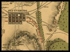
informative, and entertaining animated battle maps. Rather than just show the course of a battle through static maps, these flash-based animations such as Fredericksburg and Chancellorsville show highly detailed troop movements while providing all the information necessary to explain the battles. These maps are very useful for visually understanding the course of a battle.

Other maps include Chantilly, Cedar Creek, and Bentonville. All are worth a look.

2 comments

26

Jan

09

Interactive Look at Gettysburg from the US Army

Posted by   Published in Civil War (1861-1865), Maps, Places to Visit Themes: Battles & Soldiers

Gettysburg Interactive

The US Army has released a flash-based, interactive look at the Battle of Gettysburg . The page includes a step-by-step depiction of the battle using a topographic map with graphic overlays of the various Confederate and Union forces. Also included are profiles of various participants, weapon analysis, and other statistics. The website has plenty of valuable and interesting information. It requires Adobe Flash Player in order to run.

5 comments
Page 5 of 6« First«...23456»

Search

Categories

  • Dickinson & Slavery
  • History Online
  • Period
    • 19th Century (1840-1880)
    • Antebellum (1840-1861)
    • Civil War (1861-1865)
    • Reconstruction (1865-1880)
  • Type
    • Editor's Choice
    • General Opinion
    • Historic Periodicals
    • Images
    • Lesson Plans
    • Letters & Diaries
    • Lists
    • Maps
    • Places to Visit
    • Rare Books
    • Recent News
    • Recent Scholarship
    • Recollections
    • Video
  • What Would Lincoln Do?

Project Links

  • Digital Lincoln
  • HDiv Research Engine
  • House Divided Index
  • L-D Debates Classroom
  • Lincoln in PA
  • PA Grand Review
  • UGRR Classroom
  • Virtual Field Trips
  • William Stoker Exhibit

Administration

  • Log in
  • Entries feed
  • Comments feed
  • WordPress.org
Donate

Recent Post

  • Black Employees and Exclusive Spaces: The Dickinson Campus in the Late 19th Century
  • Friend or Foe: Nineteenth Century Dickinson College Students’ Perception of Their Janitors
  • Teaching Gettysburg: New Classroom Resources
  • Coverage of the Gettysburg Address
  • Welcome to Chicago: Choosing the Right Citation Generator
  • Augmented Reality in the Classroom
  • Beyond Gettysburg: Primary Sources for the Gettysburg Campaign
  • African Americans Buried at Gettysburg
  • The Slave Hunt: Amos Barnes and Confederate Policy
  • Entering Oz – Bringing Color to History

Recent Comments

  • George Georgiev in Making Something to Write Home About
  • Matthew Pinsker in The Slave Hunt: Amos Barnes and Confederate Policy…
  • linard johnson in Making Something to Write Home About
  • Bedava in The Slave Hunt: Amos Barnes and Confederate Policy…
  • Adeyinka in Discovering the Story of a Slave Catcher
  • Stefan Papp Jr. in Where was William Lloyd Garrison?
  • Stefan Papp Jr. in Where was William Lloyd Garrison?
  • Jon White in Albert Hazlett - Trial in Carlisle, October 1859
  • Pedro in Discovering the Story of a Slave Catcher
  • Matthew Pinsker in Register Today for "Understanding Lincoln," a New …

by Wired Studios, Corvette Garage, Jeff Mummert
© Content 2007-2010 by Dickinson College