 Nineteenth-century historian Robert Clemens Smedley labeled the town of Columbia, Pennsylvania as the birthplace of the organized structure that we now know as the Underground Railroad. Smedley’s posthumously published account of the Underground Railroad’s presence in Pennsylvania, History of the Underground Railroad in Chester and the Neighboring Counties of Pennsylvania (1883), is available on Dickinson College and Mercersville University’s digital collection: “Slavery & Abolition in the US: Select Publications of the 1800s .” Smedley narrates the story of the Underground Railroad with Columbia as a key station on the Underground Railroad because of its proximity to the Pennsylvania-Maryland border, just across the Susquehanna River. The Wright family, which founded Columbia in 1726, maintained a sympathetic ear towards the abolitionist cause reflecting their Quaker background. Today the Wright family home, Wright’s Ferry Mansion , is open to the public for tours. The founder’s grandson, William Wright, “an uncompromising hater of slavery,” became one of the first established agents of the Underground Railroad, setting up a network for escaping slaves in Columbia. Fergus M. Bordewich, author of the comprehensive Underground Railroad book Bound for Canaan (2005) mentions Wright briefly as “hitting on the idea of passing fugitives along from one home to another at intervals of ten or twenty miles, with other friends designated to pilot them in between.” Wright’s network included Robert Loney (or Loonee), a free black man who “ferried fugitives across the [Susquehanna] river in the night at various places below Columbia, and gave them into the care of William Wright.” Loney went on to join Company I of the 32nd Regiment of the USCT in 1864 and is buried in Columbia’s recently restored Zion Hill Cemetery (5th & Linden Streets, Columbia, PA), the burial place of many local black Civil War veterans. The Pennsylvania “Quest for Freedom ” tour, which maps the historic locations of abolition-related sites from Philadelphia to Chambersburg, includes a stop in Columbia that highlights the Zion Hill Cemetery. The USGenWeb Tombstone Transcription Project also includes a Zion Hill webpage with recent photos of fourteen USCT headstones.
23
Jun
10
The Battle of Fort Henry: February 6, 1862
Published in Civil War (1861-1865), Images, Maps Themes: Battles & Soldiers On February 6, 1862, Union Brigadier General Ulysses S. Grant and Union Flag Officer Andrew Hull Foote scored the first major victory for the Union Army in the Western Theater in the battle of Fort Henry along the Tennessee River near Stewart County and Henry County, Tennessee and Calloway County, Kentucky. Inundated by recent rain and flood water, the poorly conceived and outdated fort was defended by Confederate Brigadier General Lloyd Tilghman and just over 3000 Confederate soldiers. Grant and his 15,000 Union troops surrounded the fort while Foote and his seven gunboats began bombarding the fort. Foote and the Union’s naval power proved decisive as Tilghman surrendered before Grant’s soldiers even reached the fort. Estimated casualties for the battle were low with only 40 for the Union Army and just 80 for the Confederates. The victory at Fort Henry gave the Union Army access to the Tennessee River, a major water highway into the heart of the Confederate Deep South. In Ulysses S. Grant’s Civil War memoirs, he comments on the strategic importance of the capture of Fort Henry:
“With Fort Henry in our hands we had a navigable stream open to us up to Muscle Shoals, in Alabama. The Memphis and Charleston Railroad strikes the Tennessee at Eastport, Mississippi, and follows close to the banks of the river up to the shoals. This road, of vast importance to the enemy, would cease to be of use to them for through traffic the moment Fort Henry became ours.”
From Fort Henry to Corinth by Manning Ferguson Force is an available online nineteenth century resource for a narrative on the battle utilizing several maps to emphasize the importance of the strategic impact of capturing the fort is fully available on Google Books. Where the South Lost the War: An Analysis of the Fort Henry-Fort Donelson Campaign, February 1862 by Kendall D. Gott is another valuable book on the battle that can be previewed on Google Books. The Tennessee Encyclopedia of History and Culture provides an informative overview of the battle and has suggested readings for more information on the battle. The Library of Congress has a number of images and maps of the fort and surrounding areas.
22
Jun
10
The Battle of the Wilderness, May 5-7, 1864
Published in Civil War (1861-1865), Images, Lesson Plans, Maps, Places to Visit Themes: Battles & Soldiers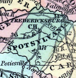
The Battle of the Wilderness (also known as Combats at Parker’s Store, Craig’s Meeting House, Todd’s Tavern, Brock Road, and the Furnaces) took place from May 5-7, 1864 in Spotsylvania County, Virginia as a part of Union General Ulysses S. Grant ’s overland campaign. Grant’s troops attacked General Robert E. Lee and the Army of Northern Virginia on May 5 and a fierce fight broke out between the soldiers. There were high casualties on both sides, including Union General James Wadsworth and Confederate General John M. Jones. The National Park Service’s website provides a detailed overview of the fighting and profiles on various historical figures that fought in the battle. Teachers may find the suggested reading list and the information for visiting the battlefield posted on the website useful for planning a fieldtrip to the area. The National Park Service also includes a virtual tour of the battleground for those that cannot make the trip as well as photos of the different sites and monuments. The Civil War Preservation Trust’s website has some interesting historical maps which may be valuable to take a look at. A study of the Battle of the Wilderness may be useful to incorporate into lessons on African American troops in the Civil War since the 43rd USCT served in the Wilderness Campaign along with other United States Colored Troop regiments. A previous post outlines the actions of the 43rd USCT during the Wilderness campaign. Gordon C. Rhea commented on the outcome of the battle in his book:
“The recent carnage could be viewed as the opening salvo of a protracted battle to end the war in Virginia. Grant’s directive represented the maturation of his thinking. Lee, Grant was conceding, could not be beaten here. But the campaign was not over. Grant would fight again, next time on the fields that offered him the upper hand. Lincoln’s new commander in chief had been checked, but not defeated. “
20
Jun
10
 In its inaugural issue published on March 15, 1862 the New South, a weekly periodical with Northern sympathies, described the Union capture of Port Royal, South Carolina on November 7, 1861 as a “brisk little engagement with the enemy at Port Royal Ferry, in which the National forces, both Army and Navy manifested pluck and coolness the most desirable qualities in soldier’s or sailors.” This newspaper, which was highlighted in a previous post, documents life in occupied Port Royal through 1866 and is available online. As part of Union efforts to enforce the executive-mandated blockade on the South, Captain Samuel F. Du Pont, commander of the South Atlantic Blockading Squadron was sent to Port Royal, South Carolina where he helped capture Fort Walker and Fort Beauregard in the largest combined naval and military operation up to that point. The Civil War Blockade Strategy Board met during the summer of 1861 created a series of reports that informed the Union’s naval blockading strategy including Du Pont’s attack on Port Royal. Matthew Parker made these reports fully available on “Thomas Legion” a website that organizes Civil War primary documents for easy research. Other useful resources include the Library of Congress’s visual time line of the Civil War, which contains a collection of photographs from Port Royal, South Carolina from 1861 to 1865, a detailed essay on the battle of Port Royal, which appeared in the January 2001 issue of America’s Civil War.
18
Jun
10
Battle of Jenkins’ Ferry (April 30, 1864)
Published in Civil War (1861-1865), Images, Maps Themes: Battles & Soldiers
The Battle of Jenkins’ Ferry took place in Grant county, Arkansas on April 30, 1864 as Confederate forces attempted to Union General Frederick Steele’s forces retreated across the Saline River. While Confederates attacked several times, they could not stop Steele’s men from crossing the river with their supplies. Andrew F. Sperry, who served with the 33rd Iowa Infantry Regiment, described the battle after the war:
“The conflict was terrible to experience, but brief to tell. Seven mortal hours, with such fierce vigor and determination that the fire of musketry became one undistinguishable and unbroken roar. Charge after charge was made by the yelling rebels, only to be broken upon our line, or if possibly succeeding for a moment, to give way at last to a charge of still deeper and more deadly determination from our own brave men.”
Confederates “forgot…the valor of Steele’s soldiers,” as another Union veteran explained.
continue reading "Battle of Jenkins’ Ferry (April 30, 1864)"
18
Jun
10
 The Battle of Ball’s Bluff, also known as the Battle of Harrison’s Island or Battle of Leesburg was fought on October 21, 1861 in Loudoun County, Virginia. In response to movement by Confederate Colonel Nathan G. Evans, Union Major General George B. McClellan ordered Brigadier General Charles P. Stone to conduct a “slight demonstration,” a show of force from the Maryland side of the Potomac River without the intention of having any troops cross or combat. After a small encounter with Confederate troops, Union soldiers were ordered to cross over the river into Virginia. Without the necessarily amount of boats, Union soldiers were unable to successfully engage the enemy. This poorly coordinated attack combined with a vigorous counterattack from Confederate soldiers led to a disastrous defeat for the Union including the death of Colonel Edward D. Baker, a United States Senator from Oregon. Estimated casualties for the Union Army totaled over 900 while the Confederates suffered only 150. The defeat had substantial political consequences in Washington D.C. with the establishment of the Congressional Joint Committee on the Conduct of the War.
Ted Ballard’s book Battle of Ball’s Bluff published by the U.S. Army Center of Military History provides the most extensive overview of the battle with a detailed account of the battle including maps, images, bibliographical sketches and further readings . The Library of Congress offers a number of resources including images of Baker’s death and the Union retreat. The Abraham Lincoln Papers at the Library of Congress is another valuable resource that contains transcribed military telegrams between generals and the President. The Ball’s Bluff Battlefield Regional Park and National Cemetery provides visitors a chance to explore the battle site with hiking trails and signs throughout the park. The Northern Virginia Regional Park Authority website also offers worthwhile information regarding the battle including an overview, cultural resources, a downloadable self guided audio tour and detailed battle maps.
18
Jun
10
The Battle of Stones River (also known as the Battle of Murfreesboro) took place from December 31, 1862- January 3, 1863 in Rutherford County, Tennessee. Confederate General Braxton Bragg and the Army of Tennessee forced Union Major General William S. Rosecrans to the Nashville Pike, but the Union Army of the Cumberland was able to regain a strong position by crossing Stones River. The Confederate forces had to retreat and abandoned the battlefield on January 4-5. The National Park Service’s website provides an essay detailing the events of the battle and maps depicting troop movement. Other tools for teachers featured on the site are traveling trunks, lesson plans and teacher guides, and exhibits which provide students with an opportunity to learn about the Battle of Stones River interactively. The Civil War Preservation Trust’ s website includes a list of recommended books for the subject as well as several related historical articles. Also available on the website are historical maps and a photo gallery. Another selection on Google Books in limited view is No Better Place to Die: the Battle of Stones River as it gives a fairly detailed preview of the battle and there are also different reports from the battle’s commanding officers in Volume 20 of the Official Records. Alexander F. Stevenson commented on this event in his account of the battle:
“At 11 o’clock that night the rebel army commenced its retreat, and long before day break its infantry was miles away on the road towards Tullahoma and Shelbyville, while their cavalry withdrew slowly at daybreak, burning bridges as they moved south. While this retrograde movement of General Bragg’s army was going on, and each hour of this Sunday night was widening the distances between contending forces, our men lay in the muddy and rain-drenched ground, ready to attack at the earliest dawn to repel the enemy’s attacks. Soon, however, a report came, incredible at first, that the enemy had evacuated Murfreesboro’. Can it be true? was in everybody’s mouth, but few believed it; others argued that some hired spy had probably brought the news, to draw us out of our position, that the battle might be continued a few miles south of Murfreesboro’.”
16
Jun
10

General William T. Sherman’s March to the Sea, also known as the Savannah Campaign, began on November 15 when Sherman’s forces left Atlanta, Georgia. The Confederate defeat at Savannah on December 21, 1864 marked the end of the campaign. Teachers can find an overview of this campaign in Professor Anne Bailey’s entry on the New Georgia Encyclopedia. The Library of Congress also has a number of related resources, including battle maps, photographs, and illustrations. In addition, the Digital Library of Georgia has all of the images from Barnard’s Photographic Views of the Sherman Campaign (1866), including several pictures of Savannah. Lt. Cornelius C. Platter’s diary, which was noted in an earlier post, is another resource that offers an interesting perspective on a Union officer’s experience. Platter, who served with the 81st Ohio Infantry Volunteers, added an entry on almost every day of the campaign. As his company prepared for their “marching orders” in early November, Platter described:
“Many different opinions have been expressed as to our probable destination – Some think we will make direct for Charleston S.C. others that we will visit Mobile – but the most general belief is that Savannah will be the objective point – Nothing definite however is known concerning the coming movement. Received orders this evening to move at six o’clock tomorrow morning – All tents and other government property which we can not take with us to be left standing undisturbed.”
continue reading "General Sherman’s March to the Sea (November – December 1864)"
16
Jun
10

The Battle of Cold Harbor (also known as Second Cold Harbor) took place in Hanover County, Virginia from May 31-June 12, 1864. As a part of the overland campaign to Richmond of 1864 General Robert E. Lee and the Confederate Army of Northern Virginia defeated Ulysses S. Grant and the Army of the Potomac. On June 3, the Union II, XVIII, and IX Corps attacked the Confederates at the Bethesda Church-Cold Harbor line and were massacred. The casualties sustained by the Union Army led Grant to say that “this charge seemed to revive [Confederate] hopes temporarily.” The National Park Service’s website provides an overview of the battle that recounts the day to day activity of the fighting as well as a list of Union and Confederate troops present at the battle. The National Parks Service’s website also includes a list of suggested readings for teachers and offers interactive travel trunks that are available for loan to classes. There is a link available that presents visitors with a map of different stops throughout a tour of the battlefield and gives suggestions for teachers to plan a fieldtrip to the battleground. The Civil War Preservation Trust ’s website has links to suggested readings, online resources, and battle facts about the events at Cold Harbor. The site includes a map that details the plan of battle for the Union and Confederate forces. Another resource that may be interesting to browse is Gordon C. Rhea’s Cold Harbor: Grant and Lee, May 26-June 3, 1864 , available in limited view on Google Books, which gives a rather detailed preview regarding the events of the battle. Grant commented on the battle in his memoirs:
“I have always regretted that the last assault on Cold Harbor was ever made. I might say the same thing of the assault of the 22 of May, 1863, at Vicksburg. At Cold Harbor no advantage was ever gained to compensate for the heavy loss we sustained. Indeed, the advantages other than those of relative losses, were on the Confederate side.”
15
Jun
10
Battle of Harpers Ferry – September 12–15, 1862
Published in Civil War (1861-1865), Historic Periodicals, Images, Maps Themes: Battles & Soldiers In October 1909 Union veteran Edward Ripley argued that the Union’s defeat at the Battle of Harpers Ferry (September 15-17, 1862) was a “tragedy:”
“It is not too exaggerated a term to use where 12,000 brave and patriotic Americans, only too willing to serve their country, were bound hand and foot by an incompetent commander and, in spite of indignant protest, handed over to the enemy.”
After General Robert E. Lee invaded Maryland, he sent General Thomas “Stonewall” Jackson to capture the federal arsenal at Harpers Ferry. Col. Dixon S. Miles ordered his forces to retreat into the town in response to Jackson’s attack, which Col. Dixon S. Miles’s response. After the war Union General Julius White argued that “[Col. Miles] had lost all confidence in his ability” and explained that the high ground around Harpers Ferry was critical to defense: “Harper’s Ferry is not defensible by a force inferior to that attacking it, unless the surrounding heights be well fortified, and each of them held by a force sufficient to maintain itself unsupported by others.”
Teachers can learn more about this battle from a short essay and related maps on the National Parks Service website. This site, which also focuses on John Brown’s attack in October 1859, also has a virtual tour and a collection of over 300 images (not all are related to the battle). Anyone planning a visit should check out the detailed information in the “Self Guided” and “Ranger Guided” sections of “Plan a Field Trip” page. Other resources are available from the Library of Congress, including historic maps, photographs, and illustrations by Alfred Waud. In addition, Cornell University’s Making of America has two articles written after the war by Confederate generals John Imboden and John Walker. Union General Julius White, whose article is referenced above, wrote it in response to these Confederate officers’ accounts, which he considered “incomplete.”


