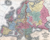
While my last post was on House Divided’s “zoomable” maps , we also have almost all of the maps from Mitchell’s 1857 atlas available. This includes all the US states and territories as well as countries and major cities from around the world. For example, check out the maps of Africa, Asia, Australia, the Carribean, Europe, England, Jerusalem, London, the Middle East, and South America. These maps can help students see how those in the 19th century saw the world that they lived in.


Related Articles
3 users responded in this post
thanks for sharing! 🙂
[…] I highlighted House Divided’s map collection a few weeks ago, another great resource is the American Geographical Society Library Digital Map […]
Nice blog, bookmarked!
Leave A Reply
Please Note: Comment moderation maybe active so there is no need to resubmit your comments