
Courthouse in Carlisle, PA – Site of the McClintock Riot in 1847.
Download as a –
SketchUp File
Courthouse in Carlisle, PA – Site of the McClintock Riot in 1847.
Download as a –
SketchUp File

In 1849, Virginia slave Henry Brown (1815-???) escaped to freedom in such a way that he became an immutable subject of Underground Railroad lore. Brown was both a well-treated and skilled slave; however, he became virulently dissatisfied with slavery when his family was sold. Brown befriended Samuel Smith, a merchant, who observed that Brown’s skill with tobacco could sustain him as a free man. Brown made up his mind to escape, and with assistance from a sympathetic free black, constructed a box with dimensions 3 feet by 2 feet by 2 feet. Brown secretly contacted the Philadelphia Anti-Slavery office, and enigmatically alluded to the pending arrival of a box that should be immediately opened. Brown then shipped himself, in the box, to the office. He arrived alive, and now, free, having endured a trek of 350 miles with 3 air holes and minimal provisions. His creative escape earned him the name, Henry “Box” Brown. J. Miller McKim and William Still of the Anti-Slavery Office were among those present at Brown’s “resurrection.”
The Journey of Henry “Box” Brown (Google Earth file)
Teacher’s Guide (Microsoft Word Document)
Social Studies Lesson Plans (Microsoft Word Document)
Interdisciplinary Lesson Plans (Microsoft Word Document)
Learn more about Henry “Box” Brown from Brown’s profile on House Divided.
Using free tools from Google Maps, we have launched a dynamic new map of Pennysylvania’s hallowed grounds that attempts to chart the burial locations of black soldiers from Pennsylvania who fought in the Civil War. In particular, this map-in-progress highlights cemeteries that hold the remains of the 100 Voices, or representative figures being memorialized by the 2010 PA Grand Review initiative. For example, three members of the 100 Voices are buried at Midland Cemetery in Steelton, Pennsylvania —Lemuel Butler, Andrew Hill and Charles Henderson. Visitors to the dynamic online map will find photographs and exact GPS coordinates of their headstones (courtesy of Calobe Jackson, Jr.) as well as background information on these men. Each online cemetery marker also includes information such as photographs or videos (where available) of the cemetery and whatever additional background information might be contained within Dickinson College’s House Divided research engine or at the Pennsylvania Grand Review website. This particular Hallowed Grounds map is ongoing project that needs your help. Please feel free to contribute photos, videos, GPS coordinates (obtainable through smart phones or GPU handsets) by sending them to us at hdivided@dickinson.edu. Other Civil War Era-related dynamic maps, such as one concerning the Underground Railroad in Pennsylvania or Frederick Douglass’s childhood in Baltimore, have been posted here.

Google SketchUp – Three dimensional models that are placed on the earth at tour sites. The application for viewing these models and creating your own models is free, and available at the Google SketchUp website.
Unfamiliar with Google SketchUp? This 3D development tool works seamlessly with Google Earth, or as a stand alone application. See a tour and tutorials at What is SketchUp?.
The SketchUp file is editable and the model can be viewed from any angle. The Quicktime Movie offers a three dimensional view of the model, but is not interactive.

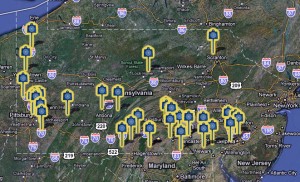
Tour of UGRR sites visited during the NEH Underground Railroad Workshops at Dickinson College
The Complete Landmarks of the Underground Railroad Tour (Google Earth File)
The Complete Landmarks of the Underground Railroad Tour with 3D models (Google Earth File – large file)

Google Earth Tour of the opening speeches and sites of the Lincoln-Douglas Debates in Illinois in 1858.
Lincoln Douglas Debates (Google Earth File)
Twelve Things You Might Not Know About
The Lincoln-Douglas Debates (Microsoft Word Document)
Learn more about these debates at the Lincoln-Douglas Debates Digital Classroom.
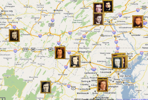 The Dickinson College Class of 1860, represented here in a Google Map, left the College just before the declaration of and start to the Civil War. By noting the birthplace and short biography of individual graduates of the Class of 1860, this map provides an important introduction to the manner with which graduates responded to the impending conflict and the inability to determine its duration or consequences. Members of the class hailed from both sides of the Mason-Dixon Line; eleven were born in Free States and thirteen in Slave States. Nonetheless, their individual lives after graduation and during the war differed in distinct ways irrespective of their birthplace. Those that did enlist in the military served, and in some cases perished, on both sides of the battlefield. Some, like Seth Hartman Yocum, took an active interest in the war and enlisted as a sergeant in Pennsylvania within a year of graduation. William T. Kinzer proved an exceptional member of the Class of 1860 who, due to financial trouble, left Dickinson without graduating. He enlisted in the Confederate army at the start of the war and served through to the Battle of Spotsylvania, during which Union soldiers captured him. He died in prison one month later. Granted, the war did not affect every graduate’s life after graduation, as many graduated and went on to become teachers, attorneys, and members of the clergy. This resource supplements other maps and virtual tours that help provide a visual of local events and locations before, during, and after the Civil War.

This section features virtual field trips, in which users create immersive experience with Google Earth by overlaying historic maps, structures, images and text, and several collections of three-dimensional models of historic structures.
Need Help? See How do I use the tour files? or How do I use the model files? for more information.
Powered by WordPress & Theme by Anders Norén